Estimation of Spatial Distribution of Dendrolimus punctatus Disaster Risk in Shizhu County Based on MaxEnt Model
-
摘要:
目的 精准掌握重庆市石柱土家族自治县马尾松毛虫害的风险范围,为及时有效地防治虫灾提供有力依据。 方法 选取60个马尾松毛虫分布点的数据,结合该县马尾松区域的地形、气候和人为因子,用MaxEnt模型估测该县的马尾松毛虫害风险。通过环境因子的百分比贡献率、置换重要性和环境因子响应曲线,探讨该县马尾松毛虫适宜生境条件。利用该模型的“训练遗漏、预测面积和阈值达到平衡”的阈值和“阈值熵与原始分布熵相等”的阈值对风险区进行风险分级,将该区域的马尾松毛虫害风险等级划分为低风险、中风险和高风险,并通过地理信息系统统计各个风险区的区域面积。通过该模型AUC均值验证估测精度,以及对比该县 2022年马尾松毛虫飞防的区域内各风险区面积占比,对风险分级效果进行验证。 结果 1)年均降水量、月均潜在蒸散发量、距居民点距离和海拔为影响该县马尾松毛虫生存的主要环境因子。2)MaxEnt模型的训练和测试的AUC均值分别为0.92与0.87,标准差为0.013,小于0.05,表明模型的结果为优,预测结果的可靠性高,可用于该县马尾松毛虫害风险估测;通过对比2022 年石柱县春季马尾松毛虫的飞防区域,面积占比高达99.05%,表明高风险区分布与其实际分布高度一致,分级效果好。3)该县马尾松毛虫害高风险区主要集中于临溪镇、悦崃镇、鱼池镇、河嘴乡和万朝镇等;王场镇、龙沙镇、王家乡、西沱镇、黎场乡、沿溪镇和万朝镇的高风险区面积占各自乡镇马尾松区域面积高达90%以上。 结论 研究表明,石柱县的马尾松毛虫害高风险区主要集中在西部和北部的乡镇,通过对乡镇间与乡镇内高风险区分布的统计分析,更全面地了解了马尾松毛虫的风险区分布,可为马尾松毛虫的针对性防治与监管提供科学依据。 Abstract:Objective Accurately grasp the risk range of Dendrolimus punctatus in Shizhu Tujia Autonomous County, Chongqing, and provide a strong basis for timely and effective pest control. Method In this paper, the MaxEnt model has been used to estimate the risk of D. punctatus in the county using the data from 60 selected distribution points of D. punctatus. These points were combined with the topographic, climatic, and human factors in the growing area of Pinus massoniana. By analyzing the contribution rate and permutation importance of environmental indicators, as well as the response curve of environmental indicators, the suitable habitat conditions of D. punctatus in this county were analyzed. The risk areas were classified using the threshold of 'balance training omission, predicted area and threshold value logistic threshold' and the threshold of 'equate entropy of thresholded and original distributions logistic threshold' of the model. The risk level of D. punctatus disaster in this area was divided into low risk, medium risk, and high risk, and the area of each risk level was calculated using geographic information system software. The accuracy of the estimation was confirmed through the mean AUC value of the model, and the efficacy of risk classification was verified by comparing the proportional areas of each risk level to the area of D. punctatus aerial control in this county in 2022. Result 1) The main environmental factors affecting the survival of D. punctatus in this county were annual mean precipitation, monthly average potential evapotranspiration, distance to settlement, and altitude. 2) The mean AUC values of training and testing of the MaxEnt model were 0.92 and 0.87, respectively, and the standard deviation was 0.013, which was less than 0.05, indicating that the results of the model were excellent and the prediction results were reliable. It can be used to estimate the risk of D. punctatus disaster in this county. By comparing the area of D. punctatus aerial control in spring of Shizhu County in 2022, the area accounted for as high as 99.05%, indicating that the distribution of high-risk areas was highly unified with its actual distribution, and the classification effect was good. 3) The high-risk areas of D. punctatus disaster in this county were mainly concentrated in Linxi Town, Yuelai Town, Yuchi Town, Hezui Town, Wanchao Town and so on. The high-risk areas of Wangchang Town, Longsha Town, Wangjia Township, Xituo Town, Lichang Township, Yanxi Town, and Wanchao Town accounted for more than 90% of the P. massoniana area in each town. Conclusion The findings indicated that the high-risk areas for D. punctatus disaster in this county were predominantly located in the western and northern towns. By conducting statistical analyses on the distribution of high-risk areas both inter- and intra-town, a more comprehensive understanding of the distribution of D. punctatus disaster in Shizhu County was achieved, offering a scientific basis for targeted prevention and management of D. punctatus disaster. -
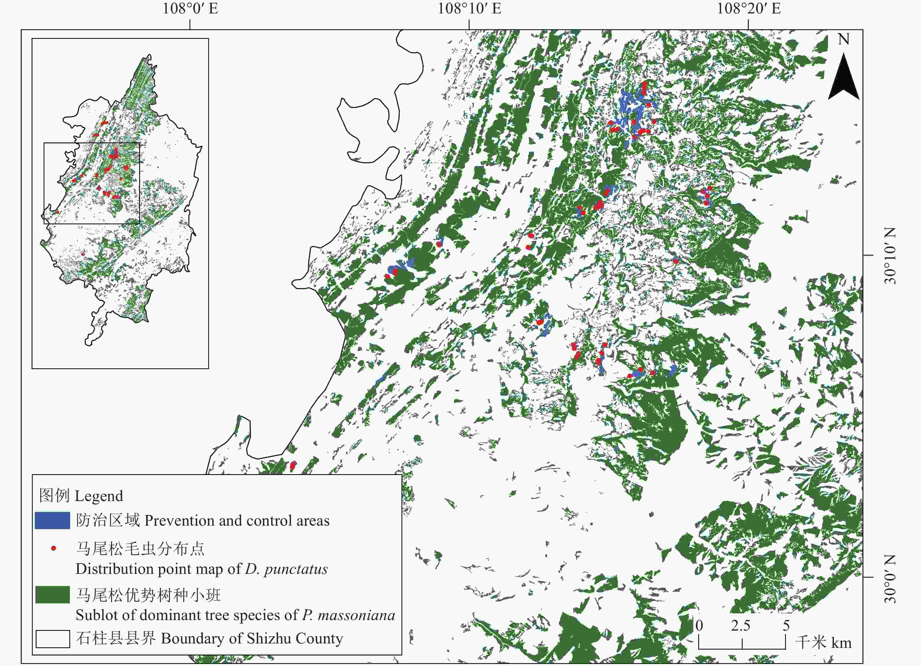
图 1 马尾松毛虫分布点的空间分布
Figure 1. Spatial distribution of Dendrolimus punctatus distribution points

图 2 石柱县马尾松毛虫害风险的主要环境因子响应曲线
Figure 2. Response curve of main environmental factors to the risk of D. punctatus disaster in Shizhu County

图 3 石柱县马尾松毛虫害风险空间分布
Figure 3. Spatial distribution of D. punctatus disaster risk in Shizhu County

图 4 石柱县临溪镇马尾松毛虫害风险空间分布
Figure 4. Spatial distribution of D. punctatus disaster risk in Linxi Town, Shizhu County
表 1 研究中所使用的环境因子指标
Table 1. Environmental indicators used in the study
类型 Type 名称 Name 单位 Unit 地形
Terrain海拔 Altitude m 坡度 Gradient ° 坡向 Aspect ° 气候
Climate年均气温 Annual average temperature ℃ 年均最高气温 Annual average highest temperature ℃ 年均最低气温 Annual average lowest temperature ℃ 年均降水量 Annual mean precipitation mm 月均潜在蒸散发量 Monthly average potential evapotranspiration mm 人为因子
Anthropogenic factors距道路距离 Distance to road m 距居民点距离 Distance to settlement m  下载: 导出CSV
表 2 环境因子贡献率及置换重要性
Table 2. Contribution rate and permutation importance of environmental indicators
环境因子
Environmental indicators贡献率
Contribution rate/%置换重要性
Permutation importance/%年均降水量
Annual mean precipitation67.8 73.4 月均潜在蒸散发量
Monthly average potential evapotranspiration9.0 5.2 距居民点距离
Distance to settlement7.9 2.1 海拔
Altitude6.7 14.3 坡度
Gradient4.2 2.1 年均最低气温
Annual average lowest temperature2.4 0.4 距道路距离
Distance to road0.8 2.2 坡向
Aspect0.7 0.4 年均气温
Annual average temperature0.5 0 年均最高气温
Annual average highest temperature0 0
下载: 导出CSV
表 3 马尾松毛虫害各风险区面积
Table 3. Areas of each risk level of D. punctatus disaster
风险分级
Risk levels石柱县 Shizhu County 防治区域 Prevention and control area 面积
Area/hm2占比
Percentage/%面积
Area/hm2占比
Percentage/%高风险 High risk 31260.06 46.70 311.58 99.05 中风险 Medium risk 2820.78 4.22 2.97 0.95 低风险 Low risk 32852.52 49.08 0 0
下载: 导出CSV
表 4 石柱县各乡镇马尾松毛虫害高风险区统计结果
Table 4. Statistical results of D. punctatus high disaster risk areas in Shizhu County
乡镇
Town村名
Villager面积
Area/hm2高风险区面积占比
Proportion of high
risk areas/%临溪镇
Linxi高建村、红阳村、花厅村、黎家村、民主村、南峰村、前光村、前进村、新街村、旭光村 4732.99 73.04 悦崃镇
Yuelai东木村、联合村、绿桃村、蜜红村、水桥村、寺院村、五岗村、新城村、悦崃村 3491.10 89.86 鱼池镇
Yuchi白江村、大坪村、黄金村、金竹村、山娇村、水田村、团结村、鱼池村 2683.46 89.87 河嘴乡
Hezui富民村、联盟村、旗峰村、双风村、同心村、银杏塘村、长沟村 2555.52 87.55 万朝镇
Wanchao万福村、万富村、万康村、万乐村、万强村、万兴村 2069.58 92.76 国有林场
State-owned forest farms茶店管护站、茨竹垭管护站、黄水管护站、江阳坝管护站、南宾管护站、三星管护站、石梁河管护站、岩口管护站 2027.53 48.54 龙沙镇
Longsha大沙村、老林村、青龙村、石岭村、永丰村、油坊村、长坪村、中海村 1831.73 95.59 桥头镇
Qiaotou马鹿村、桥头村、田畈村、瓦屋村、野鹤村、长沙村、赵山村 1805.60 73.02 石家乡
Shijia安桥村、凤凰村、黄龙村、九龙村、石龙村 1398.35 66.50 下路街道
Xialu Street白鹤村、柏树村、高鹿村、高平村、红岩村、湖海村、金彰村、上进村、双香村、天泉村、银河村、照明村 1369.72 85.60 大歇镇
Daxie大歇村、方斗村、干柏村、高扬村、黄山村、流水村、龙泉村、龙王村、双坝村、双会村 986.25 68.21 三星乡
Sanxing观音村、雷庄村、三树村、石星村、五斗村、下塘村 934.80 32.45 王家乡
Wangjia光华村、花源村、蜜园村、山泉村、五岭村、雄风村 925.38 95.48 王场镇
Wangchang大坝村、蛟鱼村、秦家村、石溪村、双龙村、双星村、太和村 792.21 99.21 沿溪镇
Yanxi滨江村、陡岩村、静观村、坡口村、清明村、清溪村、新阳村 656.69 92.91 三益乡
Sanyi大堡村、新田村、寨上村、中堆村 589.72 72.87 西沱镇
Xituo黄角岩村、南坪村、太平桥村、西山村、玉石村、朱家槽村、竹景山 586.67 94.99 六塘乡
Liutang大塘村、高龙村、黄腊村、回龙村、六塘村、平桥村、三汇村、三坪村 480.61 7.70 黄水镇
Huangshui大风堡村、黄水村、金花村、清河村 442.22 46.95 南宾街道
Nanbin Street城北村、河坝村、红井村、红星村、黄鹤村、梁峰村、双庆村、勇飞村 310.22 45.56 中益乡
Zhongyi光明村、华溪村、龙河村、坪坝村、盐井村 277.34 6.36 三河镇
Sanhe白玉村、蚕溪村、大河村、拱桥村、红明村、三店村、四方村、万寿寨村、鸭庄村、永和村、玉岭村 135.03 81.24 沙子镇
Shazi青园村、沙子村、星光村、兴隆村、鱼泉村 112.94 1.79 万安街道
Wanan Street宝坪村、城南村、灯盏村、华丰村、黄鹿村、龙坪村、沙谷村 44.55 22.16 枫木乡
Fengmu昌坪村、国峰村、莲花村 6.57 7.26 洗新乡
Xixin五坪村 1.44 0.12 黎场乡
Lichang深溪村 0.05 94.35
下载: 导出CSV
-
[1] 陈基近, 符忆华, 2020. 马尾松常见病虫害防治方法探究[J]. 南方农业, 14(8): 60-61. doi: 10.19415/j.cnki.1673-890x.2020.08.032 [2] 韩大校, 王烁, 张瑜, 等, 2023. 松毛虫发生的驱动因素及灾害控制技术的研究进展[J]. 温带林业研究, 6(3): 52-56. doi: 10.3969/j.issn.2096-4900.2023.03.009 [3] 韩瑞东, 何忠, 戈峰, 2004. 影响松毛虫种群动态的因素[J]. 昆虫知识, (6): 504-511. doi: 10.3969/j.issn.0452-8255.2004.06.002 [4] 侯陶谦, 1993. 中国松毛虫防治研究进展[J]. 森林病虫通讯, (2): 40-42. [5] 孔维尧, 李欣海, 邹红菲, 2019. 最大熵模型在物种分布预测中的优化[J]. 应用生态学报, 30(6): 2116-2128. doi: 10.13287/j.1001-9332.201906.029 [6] 李明洁, 2023. 基于MaxEnt模型的东北地区松毛虫害风险评估与预测[D]. 长春: 吉林大学. [7] 李霓雯, 张晓丽, 张凝, 等, 2019. 基于加权信息量模型的油松毛虫灾害发生危险性评价[J]. 林业科学, 55(3): 106-117. doi: 10.11707/j.1001-7488.20190312 [8] 庞永华, 冀小菊, 2019. 基于机器学习的马尾松毛虫发生面积预测模型[J]. 江西农业学报, 31(5): 55-58. doi: 10.3969/j.issn.1001-8581.2019.05.010 [9] 田开慧, 陈怡帆, 周宏威, 2022. 湖南湘西州马尾松毛虫和松材线虫病发生非线性建模与预测[J]. 森林工程, 38(6): 38-44. doi: 10.3969/j.issn.1006-8023.2022.06.005 [10] 武红敢, 王成波, 苗振旺, 等, 2021. 森林资源亚健康状态的卫星遥感预警技术研究[J]. 遥感技术与应用, 36(5): 1121-1130. doi: 10.11873/j.issn.1004-0323.2021.5.1121 [11] 吴思俊, 朱天辉, 谯天敏, 2021. 基于物种分布模型对未来气候变化下云南松毛虫在四川省适生区的预测[J]. 植物保护学报, 48(4): 882-890. doi: 10.13802/j.cnki.zwbhxb.2021.2020124 [12] 吴艳, 王洪峰, 穆立蔷, 2022. 物种分布模型的研究进展与展望[J]. 高师理科学刊, 42(5): 66-70. doi: 10.3969/j.issn.1007-9831.2022.05.012 [13] 萧刚柔, 1992. 中国森林昆虫(增订本)[M]. 2版. 北京: 中国林业出版社. [14] 许格希, 余荣兵, 杨昌旭, 等, 2023. 基于GIS空间技术和MaxEnt模型预测川西松材线虫病入侵风险[J]. 北京林业大学学报, 45(9): 104-115. doi: 10.12171/j.1000-1522.20220527 [15] 张真, 李典漠, 2008. 马尾松毛虫暴发机制分析[J]. 林业科学, 44(1): 140-150. doi: 10.3321/j.issn:1001-7488.2008.01.023 [16] 重庆市石柱土家族自治县人民政府, (2022-07-12) [2024-01-08]. 石柱土家族自治县人民政府关于印发《石柱土家族自治县“十四五”自然资源利用和发展规划(2021—2025年)》的通知[EB/OL]. http://cqszx.gov.cn/zwgk_260/zcwj_xzf/qtgw/202208/t20220831_11058438.html. [17] 宋雄刚, 王鸿斌, 张真, 等, 2016. 应用最大熵模型模拟预测大尺度范围油松毛虫灾害[J]. 林业科学, 52(6): 66-75. doi: 10.11707/j.1001-7488.20160608 [18] Boubli J, Lima M G D, 2009. Modeling the geographical distribution and fundamental niches of Cacajao spp. and Chiropotes israelita in northwestern amazonia via a maximum entropy algorithm[J]. International Journal of Primatology, 30(2): 217-228. doi: 10.1007/s10764-009-9335-4 [19] Hernandez P A, Franke I, Herzog S K, et al, 2008. Predicting species distributions in poorly-studied landscapes[J]. Biodiversity and Conservation, 17(6): 1353-1366. doi: 10.1007/s10531-007-9314-z [20] Kumbula S, Mafongoya P, Peerbhay K, et al, 2019. Using Sentinel-2 multispectral images to map the occurrence of the Cossid moth (Coryphodema tristis) in Eucalyptus nitens plantations of Mpumalanga, South Africa[J]. Remote Sensing, 11(3): 278. doi: 10.3390/rs11030278 [21] Pearson R G, Dawson T P, 2003. Predicting the impacts of climate change on the distribution of species: are bioclimate envelope models useful?[J]. Global Ecology and Biogeography, 12(5): 361-371. doi: 10.1046/j.1466-822X.2003.00042.x [22] Phillips S J, Anderson R P, Schapire R E, 2006. Maximum entropy modeling of species geographic distributions[J]. Ecological Modelling, 190(3/4): 231-259. doi: 10.1016/j.ecolmodel.2005.03.026 [23] Phillips S J, Dudik M, Schapire R E, 2004 [2024-01-08]. A maximum entropy approach to species distribution modeling[R/OL]. Proceedings of the twenty-first international conference on Machine Learning. New York, NY, USA: Association for Computing Machinery, 655-662. https://doi.org/10.1145/1015330.1015412. [24] Swets J, 1988. Measuring the accuracy of diagnostic systems[J]. Science, 240(4857): 1285-1293. doi: 10.1126/science.3287615 [25] Warren D L, Wright A N, Seifert S N, et al, 2014. Incorporating model complexity and spatial sampling bias into ecological niche models of climate change risks faced by 90 California vertebrate species of concern[J]. Diversity and Distributions, 20(3): 334-343. doi: 10.1111/ddi.12160 -


 点击查看大图

计量
- 文章访问数: 89
- HTML全文浏览量: 41
- PDF下载量: 18
- 被引次数: 0